


Hiland Precinct, Anchorage Municipality, Alaska
About
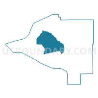
Outline

Summary
| Unique Area Identifier | 523221 |
| Name | Hiland Precinct |
| County | Anchorage Municipality |
| State | Alaska |
| Area (square miles) | 204.45 |
| Land Area (square miles) | 203.77 |
| Water Area (square miles) | 0.68 |
| % of Land Area | 99.67 |
| % of Water Area | 0.33 |
| Latitude of the Internal Point | 61.15330320 |
| Longtitude of the Internal Point | -149.38669670 |
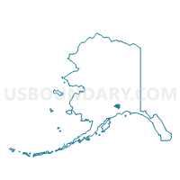
Maps

Graphs
Select a template below for downloading or customizing gragh for Hiland Precinct, Anchorage Municipality, Alaska


Neighbors
Neighoring Voting District (by Name) Neighboring Voting District on the Map
- Bear Valley Precinct, Anchorage Municipality, AK
- Centennial Park Precinct, Anchorage Municipality, AK
- Chugach Foothills No. 1 Precinct, Anchorage Municipality, AK
- Chugach Hills No. 2 Precinct, Anchorage Municipality, AK
- Chugach Park No. 1 Precinct, Anchorage Municipality, AK
- Downtown Eagle River No. 1 Precinct, Anchorage Municipality, AK
- Eagle River No. 1 Precinct, Anchorage Municipality, AK
- Eagle River No. 2 Precinct, Anchorage Municipality, AK
- Fort Richardson Precinct, Anchorage Municipality, AK
- Girdwood Precinct, Anchorage Municipality, AK
- Indian Precinct, Anchorage Municipality, AK
- Lore No. 1 Precinct, Anchorage Municipality, AK
- Muldoon No. 1 Precinct, Anchorage Municipality, AK
- Muldoon No. 2 Precinct, Anchorage Municipality, AK
- Muldoon No. 3 Precinct, Anchorage Municipality, AK
- North Muldoon Precinct, Anchorage Municipality, AK
- Stuckagain Heights Precinct, Anchorage Municipality, AK
Top 10 Neighboring County Subdivision (by Population) Neighboring County Subdivision on the Map
Top 10 Neighboring Place (by Population) Neighboring Place on the Map
Top 10 Neighboring Unified School District (by Population) Neighboring Unified School District on the Map
Top 10 Neighboring State Legislative District Lower Chamber (by Population) Neighboring State Legislative District Lower Chamber on the Map
- State House District 32, Chugach State Park, AK (19,952)
- State House District 18, Military, AK (19,255)
- State House District 30, Lore-Abbott, AK (18,664)
- State House District 19, Muldoon, AK (17,804)
- State House District 17, Eagle River, AK (16,349)
- State House District 21, Baxter Bog, AK (16,303)
Top 10 Neighboring State Legislative District Upper Chamber (by Population) Neighboring State Legislative District Upper Chamber on the Map
- State Senate District P, AK (37,696)
- State Senate District J, AK (36,344)
- State Senate District O, AK (36,303)
- State Senate District I, AK (35,604)
- State Senate District K, AK (32,429)
Top 10 Neighboring 111th Congressional District (by Population) Neighboring 111th Congressional District on the Map
Top 10 Neighboring Census Tract (by Population) Neighboring Census Tract on the Map
- Census Tract 2.03, Anchorage Municipality, AK (10,549)
- Census Tract 3, Anchorage Municipality, AK (8,000)
- Census Tract 17.32, Anchorage Municipality, AK (6,179)
- Census Tract 17.31, Anchorage Municipality, AK (5,823)
- Census Tract 7.03, Anchorage Municipality, AK (5,706)
- Census Tract 28.23, Anchorage Municipality, AK (5,217)
- Census Tract 28.13, Anchorage Municipality, AK (4,579)
- Census Tract 2.01, Anchorage Municipality, AK (4,110)
- Census Tract 2.04, Anchorage Municipality, AK (3,381)
- Census Tract 29, Anchorage Municipality, AK (2,570)
Top 10 Neighboring 5-Digit ZIP Code Tabulation Area (by Population) Neighboring 5-Digit ZIP Code Tabulation Area on the Map
- 99504, AK (40,914)
- 99507, AK (37,850)
- 99577, AK (25,771)
- 99516, AK (20,095)
- 99506, AK (7,749)
- 99505, AK (6,174)
- 99587, AK (2,250)
- 99540, AK (320)